Tuesday, December 17, 2013

Our Teddy at Tulum


Ola Kids,

Can you guess where I went on my most recent adventure?  Somewhere where they speak Spanish!  Somewhere where it is warm in the winter.  It's Mexico!  If you look at a map, you'll see that Mexico is south of the United States.  See how it swoops down like a big tail?  We were at the top of the tip of the tail near Cancun in the state of Quintana Roo.  This whole part of the tail is called the Yucatan peninsula.  The word penisula comes from two Latin words which mean "almost an island."  The peninsula is bordered by water on three sides.  One more side and it would be an island!

This part of Mexico is the home of the Mayan civilization -- one of the great cultures of North America.  We visited Tulum -- the ruins of one of the important Mayan cities.  The Mayan civilization here was very prosperous from about 1200 to 1550 A.D. -- then, about 550 years ago, it almost disappeared.  It's cities lay in ruins, hidden in the jungle.  For about 300 years, Tulum was completely forgotten.  It was rediscovered in 1840 and today is a major tourist attraction in the area.   

This is Froylan, our guide, who showed us Tulum.  The city was located on the edge of tall cliffs but had a small harbor and was a major port for the early Mayans.  Froylan told us that experts believe about 500 people -- the richest and most important -- lived inside the thick walls that surrounded the city.  About 2000 more people lived outside the walls.  You can see how thick the walls are.


Inside the walls, the grass is lush and green but scattered with stones that show where original buildings stood.  Some of the buildings have been rebuilt so people can get a better idea of what the city would have looked like.  Many of the original stones still show traces of carvings of Mayan gods.  The largest building is called El Castillo -- the castle -- and scientists think it may have been used as a light house to guide sailors.  Other buildings were used for religious purposes or as houses.


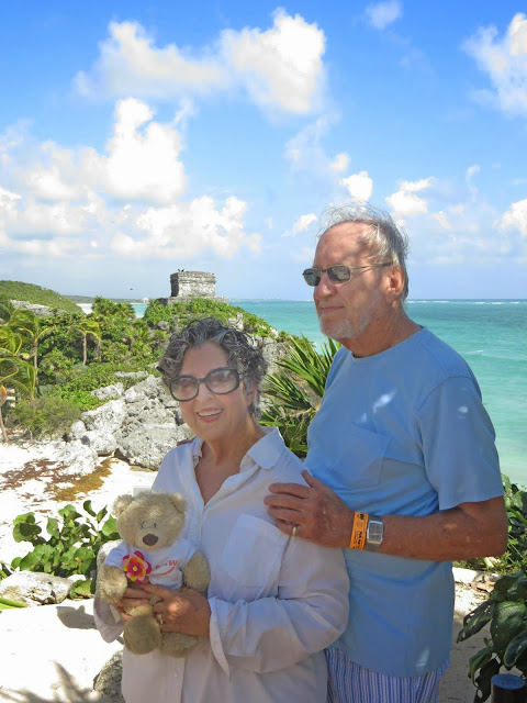
Miss Elaine took this picture behind El Castillo.  The little building you can see in the picture is called the Temple of the Wind (Templo del Viento in Spanish).  Isn't this a beautiful place!


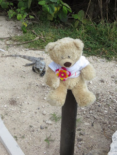
There were lots of large lizards called iguanas running around the ruins.  Miss Elaine wanted to take my picture with one.  I wasn't so excited about it.


I don't think he was excited about it either.  Here is a close-up picture of him.

 
Miss Elaine, Mr. Jack and I had a great time exploring Tulum.  We hope you enjoyed our pictures.
Love,
Lily

Tuesday, November 12, 2013

Quebec City


Hi Kids,
It's me -- Tiger!  Lily is letting me send you a post to tell you about the trip I took this summer.  I went to Quebec City in the province of Quebec in Canada.  A Canadian province is kind of like one of our states.
Quebec is an unusual province because it is very French while most of Canada is more English.  Even the people here speak French although most of them can also speak English.  In the picture above you can see part of the old city walls behind me.  In olden times, the city was built inside and protected by huge stone walls.  Today that historic part of the city is full and the town has spilled out beyond the walls.


The town is very old and very beautiful.  It gets really cold in the winter but summers are lovely and people enjoy being outside.


This is me with the concierge at the hotel.  He is helping me mail the post card I sent to you!  Have you ever seen such a fancy mailbox?  (Is concierge a new word to you?  Pronounce it con-see-airzh.  It means someone who helps hotel guests with questions about where to go, what to see and where to mail a post card!)

This is me with Steeve Gaudreault.  He was our guide on a tour of the town.  He knows a lot about history and is dressed up as Louis Hebert, the first permanent settler in Quebec.  Quebec City was founded in 1608.  Louis Hebert (pronounced Loo-ee Ay-bear) came to the area in 1617 and settled with his family.  Don't ask me to pronounce Steeve's last name!


A good way to see the city is by horse and carriage.  There are many beautiful old buildings in the town -- particularly in the historic areas.

One of the most famous Quebecois (Kuh-bec-waz) is Louis Joliet.  He was a French-Canadian explorer who explored and mapped much of the Mississippi River.  This is an actor dressed up as Joliet.  He shared a lot more history with us as we sailed down the St. Lawrence River.  This is a very large river -- 744 miles long -- which connects the Great Lakes to the Atlantic Ocean.  


The streets in old Quebec are very narrow.  Old Quebec consists of two parts -- the oldest part is Lower Quebec, right on the river bank.  Now the area is full of interesting shops and restaurants -- and this lovely little park.


The larger part of Old Quebec is the upper part -- atop the cliffs.  It's a steep climb, so most people take the funicular -- a sort of elevator on tracks.  


Miss Elaine and I were invited to Quebec to see the International Military Band Festival.  We love music.  And we loved this man.  His name is Boris Dykov and he and two other singers came from Russia to sing in some parts of the concerts.  He had a booming baritone voice.  Men's voices are divided into three types.  Men with high-pitched voices are tenors.  Men who can sing very low notes are called basses.  And the baritones sing in the middle.

The final concert was very exciting.  Each band performed individually but on the last pieces, they played altogether.  There were over 700 musicians.  I wish you could have heard it.  It was so wonderful I got goosebumps under my fur!
I hope you enjoyed hearing about my trip.  Maybe Lily will let me write you again sometime.
Love,
Tiger

Saturday, September 21, 2013

Mountain Adventures

 Hi Kids,
This is me sitting next to a cone formed by mineral deposits from hot, hot water coming up from deep underground.  I'm at Pagosa Springs in southern Colorado.  The water coming out of the springs here is
way too hot to touch but people here have figured out some great ways to use it.  We stayed at the Springs Resort.  They mix the hot water with different amounts of cold water to make a whole bunch of hot tubs.  You can choose the temperature you like.

The hotel and springs are on the banks of the San Juan River.  Lots of kids were tubing in the river.  Where you see the blue shades, that's where some of the hot pools are.
Miss Elaine and Mr. Jack liked to get in the hot pools after it turned cool in the evening.  I stayed in our room and kept Roxie, the dog, company.  I really don't like getting my fur wet!
One day we visited an artist's studio.  Fred Harman was a cowboy artist and a cartoonist.
 This is me with a sculpture of Red Ryder, Mr. Harman's most famous creation.  His comic strip about Red Ryder and his adopted son, Little Beaver, ran in newspapers in many parts of the world.  It was so popular that there were also Red Ryder books and movies.
I felt pretty popular when the newspaper in Pagosa Springs took my picture and put it in the paper.  The story told about how I get to travel and share my adventures with you.
Pagosa Springs is in this beautiful valley in the San Juan Mountains which are part of the Rocky Mountain chain.
The Rocky Mountains are sometimes called the spine of America.  They are the place where waters divide.  Water that falls on the west side of the imaginary line called the Continental Divide flows west eventually winding up in the Pacific Ocean.  Water that falls on the east side of the line flows south and east to the Gulf of Mexico and the Atlantic Ocean.  I'm sitting on the spot where the waters divide!
Love,
Lily

Tuesday, July 2, 2013

We A-Door Ann Arbor!


 Hi Kids,

This is me at a fun outdoor food court in Ann Arbor, Michigan.  The weather was great and Miss Elaine and I had some great adventures.  I miss Tiger -- he's with Miss Kysar now -- but I'm glad I'm still traveling with Miss Elaine.  We spent a lot of time exploring downtown Ann Arbor.  But we never saw my favorite things until, one night at dinner, someone said, "Have you seen the fairy doors?"

Miss Elaine and I set out the next morning to look for the tiny doors that many believe were made by little magical creatures.  We discovered we'd passed right by some of them without ever noticing them in the days before. 

In front of a shop called Peaceable Kingdom, we found this little girl, Lillian, looking at one of the doors.
 
When we went inside the shop, we could look into a window into the fairy store.


Some of the doors were easy to spot -- and looked like the doors to the people-sized buildings.


Often children leave little presents on the doorsteps for the fairies.  Cheerios, M&Ms and even pennies are popular presents.  Someone left some flowers on this doorstep, too.


We loved it that the fairies have their own bank and ATM at the back of a big bank.


Ann Arbor is the home of the University of Michigan.  This is the bell tower on the main campus.  Inside the tower is a set of 53 bells which can be rung by using a special keyboard arrangement of stick-like batons.  Players strike the batons with their fists.


The bells are really big.  The biggest bell weighs 42 tons.  That's more than 84 horses.  A set of bells like this is called a carillon.  These bells don't swing -- instead they are hit by hammers like the one below.


 Miss Elaine got to play the carillon.  She played "Amazing Grace" and only hit one wrong note. 


There are some really cool museums on the University campus.  This is me in front of some very old jugs.  They were used by either Greeks or Romans to store wine or olive oil.  There were Egyptian mummies in the museum, too, but it was too dark to get a good picture.


My favorite museum was the Natural History Museum.  It had lots of things in it but I liked the dinosaurs best.  Miss Elaine thought it would be funny to take my picture in the mouth of a strange prehistoric creature called a basilosaur.  It lived 37 million years ago.  It looked kind of like a huge lizard but was really a whale.

I hope you're having a good summer and a having good adventures, too.
Love,
Emily

Wednesday, May 15, 2013

The REALLY Grand Canyon


Hi Kids,
Well, this was our last journey of the year -- and it was a good one!  Mr. Jack, Miss Elaine, Emily and I took the train from Williams, Arizona, 60 miles to the Grand Canyon.  The train was really neat.  The car we were in was a double-decker and we were on top.  It's called a vistadome  (vista means view) and we could see everything on both sides of the train.  They served us snacks, too.  We all liked those!


This is Emily at the Grand Canyon.  Miss Elaine is always careful not to put us in dangerous spots.  It was a loooooonnnnnggggg way down to the bottom of the canyon -- about a mile.


If you look hard, you can see a squiggly line going down into the canyon.  People walk down it to get to the bottom.  Some of them ride mules down.  I think it would be very scary so I'm glad we didn't have time to do it.
 

This is me, Tiger, at another spot on the rim of the canyon.  The canyon is HUGE!  It runs for about 277 miles -- farther than the distance from Edmond to Dallas!  It is impossible to take a photograph that gives you the true idea of what it looks like.  You can only see little pieces at a time.  But Miss Elaine did her best -- she came home with over 1000 pictures from our trip.  (No, you don't have to look at all 1000!)


Do you see that river in the bottom of the canyon?  That's the Colorado River.  Over millions of years that river carved the canyon into the flat land you can see on top of the canyon.  As the river cut deeper into the earth, it revealed many layers of rock.  The dark rocks right by the river are some of the oldest rocks on earth.  The higher in the canyon you get, the younger the rocks are.  Geologists can "read" the layers to learn how the land was formed.
 

Here's a secret if you like taking pictures.  Pictures taken late in the afternoon or early in the morning are often prettier because of the light.  Look at some of the earlier pictures in this post.  They are nice but not as colorful as this one.  Miss Elaine took this right before sunset.


She took this picture just as the sun was coming up -- at 5:43 in the morning.  It was really cold that morning.  Emily and I were glad she let us stay in bed!  See how the early light turns the rocks a more brilliant yellow and red?


We loved the Grand Canyon but soon it was time to get back on the train.  Our adventures weren't over, though.  As we were coming back to Williams, we looked out the window and saw masked men on horses racing beside the train.  Soon the train stopped.  Robbers!  (But not real ones!)  They came through the train and pretended to rob the passengers -- just like train robbers used to do in the Old West.  Emily and I played along with their game.  And we got home safely!
 
It's been a great year and Emily and I have enjoyed sharing our travels with you.  There are lots of wonderful places to see and people to meet.  We hope you have a great summer.  We'll be staying with Miss Kysar and Mrs. Beasley so maybe you could come say "hi" next year when you are 3rd graders.
Love,
Tiger and Emily (and Miss Elaine and Mr. Jack)

Sunday, May 12, 2013

Original residents


 Hi Kids,
While Tiger and I were exploring Arizona, we discovered a lot about early people who lived here.  The Native Americans who constructed this amazing building lived here over 600 years ago.  We don't know what they called themselves, but the first Spanish explorers called their descendants "Sinagua," which means "without water."

They built their homes into cliffs, using caves in the rock and then building with rock and mud to create rooms and walls.  This particular structure was later named Montezuma
Castle -- after a South American Aztec chief.  


 This is a nearby complex that hasn't survived as well.  The Indians abandoned this site around the year 1400 -- before Columbus, before the Spanish explorers.  We don't know why. 
 Naming the natives Sinagua seems silly.  The Indians were very smart -- they built their homes near water.  This is the stream that flows through the bottom of the canyon.  Life must have been very difficult.  Their houses were high in the cliffs and hard to reach.  Why do you think they built them there?

 We saw more Native American settlement around this beautiful and mysterious pool, called Montezuma Well.  It is mysterious because no one knows how deep it is.  It has a strange false bottom of swirling sand and when scientists try to push measuring instruments into it, the water pressure pushes them out.

Can you see the houses built just under the edge of the cliff?


 This is me, Emily, sitting on a wall over Walnut Canyon.  The Indian houses here are even harder to see -- and harder to get to.

Look very carefully for large holes -- these were once Indian homes.  The model below shows how the Indians got up and down the cliffs.  They grew food on the top of the cliffs, lived in the cliffs and had to carry water up from the bottom of the canyon.  Aren't you glad we don't have to do that?   See you soon.
Love,
Emily and Tiger